Companies in almost every industry use drones, also known as unmanned aircraft systems (UAS) for inspections, especially in industries where maintenance procedures call for visual asset inspections. By performing frequent drone inspections, companies save time, keep the environment and employees safe, and ensure that assets function efficiently and failures don't hurt the bottom line.
This article will dive into four drone inspection use cases where drone operators add specific solutions to their drones to collect data. Once processed and expertly labeled, this high-quality data helps companies perform advanced data analytics leading to safe, accurate, and efficient inspections. In some cases, this data is used to train computer vision training models, allowing the drone to operate at a Level 3 autonomy. The four use cases we will examine are:
- Inspecting power lines and utility poles
- Inspecting mines
- Inspecting oil and gas pipelines
- Inspecting bridges
In all of the above use cases, drone data comes from many sources, including images and videos, thermal and OGI, terrain maps, and 3-D cloud points using LiDAR technology.
1. Inspecting Power Lines and Utility Poles
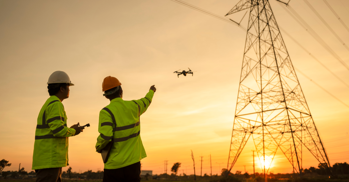
AI-enabled drones can fly every day and use visual data to identify potential issues early, reducing the number of power outages to your customers.
Inspectors usually conduct power line and utility pole inspections on foot, by car, or in a helicopter, with most inspections taking place on the ground. The problem with ground-based inspections is that if inspectors suspect an issue, they may use a lift to take a closer look—and lifts can be dangerous. For rural power lines and utility poles, rough terrain makes walking or driving challenging and incredibly slow. Helicopters are noisy, ecologically unsustainable, and expensive. For example, an average power-line inspection by helicopter exceeds $4,000 per day. If a utility company purchases a helicopter, the cost can easily exceed $2 million.
Drones offer a quieter, cleaner, cheaper option for power line and utility pole inspections. They’re also much safer because drones are unmanned; no one needs to be inside the drone flying at low altitudes parallel to electrified power lines and poles.
Drone inspection of power lines and poles can use cameras, LiDAR, color (RGB), and hyperspectral and thermal imagery sensors to quickly canvas the area and collect data that would otherwise require workers to traverse potentially hazardous working conditions. Together, these millions of data points create 3-D images and give inspectors a highly accurate snapshot of power lines and poles. Also, a drone inspects power lines and utility poles from an overhead view, where most power lines and pole damage tend to be. These overhead views give inspectors a much clearer picture of potential damages, ultimately keeping them safer and limiting the number of times they need to go up in a lift.
PrecisionHawk uses AI-enabled drones equipped with failsafe features that enable the drone to fly low and slow to capture rich RGB and LiDAR data from various angles. Utility companies can then track changes to the power lines and poles over time and plan repairs and renovations.
2. Inspecting Mines
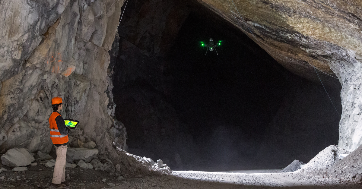
Adding autonomy to drones means inspectors don't need to be exposed to falling debris or noxious fumes.
Mining is a hazardous industry. Therefore, the Mine Safety and Health Administration (MSHA) requires 2-4 health and safety compliance inspections per year. In the United States, underground mines are inspected four times a year, while surface mines have two inspections per year. Mines with higher levels of explosive or toxic gases face more inspections, and MSHA also conducts inspections to respond to complaints of hazardous conditions.
As a result, the mining industry is readily adopting drone technology into its operations. In fact, the popularity of drones across the mining industry has grown immensely in recent years. In 2020, the Global Mine-Site Technology Adoption Survey of 158 mine sites reported that 30% of mine sites planned to make considerable investments in drone technology. Because drones help keep workers safe, the mining industry is one of the fastest commercial adopters of drones, and research shows that mining fatalities are decreasing in American mines. A recent report from Statistica Research indicates that work-related accidents in the mining industry went from 72 fatalities in 2010 to 29 in 2020, some of which could result from the increased use of drones in the mining industry.
By using a drone, inspectors don’t have to enter confined spaces, be exposed to falling debris or traces of noxious fumes, or stand on scaffolding at dangerous heights. Emesent’s Hovermap for Mining can be attached to drones to offer a complete mobile LiDAR mapping solution. Hovermap’s rotating LiDAR provides an omnidirectional field of view that allows the drone to collect 3-D point cloud data in all directions. This helps companies pinpoint potential risks to machinery and explore areas of a mine where a human inspector could never reach.
Drones also can detect hazardous gas in underground mines. DJI produces gas sensors that help to measure coal fire gasses. The sensors also include powerful analytics software that can generate 2-D grid maps, 2-D contours, and 3-D point clouds at a sub-second response rate to enable real-time monitoring of mines.
3. Inspecting Oil & Gas Pipelines
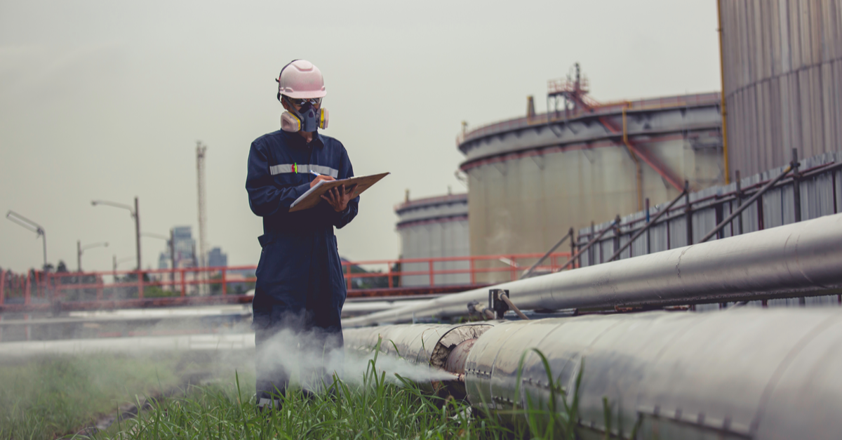
Rather than putting employees in harm's way, drones allow close-up visual and thermal observations – easily accessing what human teams can’t.
Pipelines within the oil and gas industry need regular inspection to prevent bursts, punctures, fractures, and buckling. In traditional pipeline inspections, entire facilities are often halted so a team of inspectors can safely drive, walk, or use a helicopter to assess the asset. The team will photograph, document, and inspect many checkpoint items along the pipeline. They often measure the depth and alignment of trenches and examine the trenches for stones or debris that may damage the pipeline. An inspector may also collect data on the surrounding area for possible corrosion factors. These traditional pipeline inspections are challenging because of the need to inspect the vast distribution networks and varied terrain these pipelines often pass through.
Adding advanced data analytics, post-processing, and autonomy to drones for pipeline inspection is a non-intrusive method for inspections. The drones can inspect large areas of the network over various terrains and reach areas that are not accessible by humans. In addition, pipeline operations do not need to be shut down for a drone inspection, increasing uptime for the business. Drones use a variety of sensors and cameras to gather data that will indicate if there is physical or mechanical damage, corrosion, equipment defects, natural conditions that could lead to pipeline failure.
Sharper Shape uses AI-based high-resolution image, video, and thermal cameras, combined with LiDAR and other sensors to provide a faster, safer, more accurate, and cost-effective data collection solution for many oil and gas inspections, including pipelines. Their autonomous capabilities enable automated flight paths and custom data-capture profiles for individual structures. Detect and avoid technology helps their drones avoid obstructions, and in emergency events, a drone can be immediately deployed for automated damage assessment, minimizing risk to personnel.
4. Inspecting Bridges
AI-enabled drones can navigate BVLOS using detect and avoid technology to inspect hard-to-reach areas of bridges.
According to Market Screener, 42% of American bridges are over 50 years old and require regular inspections to ensure their structural health. Conventional bridge inspections are usually performed using a snooper truck. A snooper truck is considered dangerous because it can critically injure or even kill crew members when they malfunction. Traditional bridge inspections are also costly, and those costs increase significantly if interruptions occur because of problems with lane closures and traffic on the bridge.
To combat rising costs, bridge inspection companies are investing more and more in AI-enabled drones as an alternative solution for conducting inspections. According to GIM International, drones are up to 75% cheaper to operate than manual inspections, do not affect the flow of traffic, and are environmentally friendly. In bridge inspections, drones use AI-enabled sensors to efficiently capture and localize any critical information such as defects or maintenance issues while safely navigating complex, GPS-denied environments using detect and avoid technology.
Skydio is one company heavily invested in AI-enabled drones for bridge inspections. The North Carolina Department of Transportation received the first-of-its-kind, state-wide FAA beyond visual line of sight (BVLOS) approval to inspect bridges using Skydio drones. The company conducts BVLOS drone inspections that enable workers to inspect more expansive areas, larger structures, and dangerous or difficult-to-reach environments while reducing visual observer and surveillance costs.
Drones Create Digital Twins of Bridges
Another exciting way drones can help preserve structural health is by gathering the large amount of data needed to create digital twins, a digital representation of a physical asset that allows its performance to be understood and modeled.
According to a 2021 article from MDPI, “digital twins are suitable alternatives to in-person and on-site based assessments that can provide safer, cheaper, more reliable, and less disruptive bridge inspections.” A digital twin combines data from continuous surveys, photogrammetry, LiDAR, and other sensors to track changes to a bridge over time. This enables owners to view the digital representation of the bridge and related real-world conditions over time to track and understand information such as the exact size of cracking, corrosion, or section loss, rather than trying to determine this information by manual inspections.
Bentley creates digital twins to help inspectors inspect large areas of a bridge while in the office. This reduces the time spent in the field, which saves time and money and increases safety. Digital twins also give inspectors flexibility to conduct more in-depth inspections without having to schedule expensive equipment and labor.
Drone Inspections Are Here to Stay
These four use cases represent just a tiny sample of how drones gather and use data to improve inspections.
The proper post-processing of data and quality image annotation are critical steps in preparing the enormous amount of data inspectors require to inspect assets properly. In addition, there is no room for error when it comes to the data that improves drone inspections, as inaccurate data can lead to erroneous reporting, wasted time and money, and injury or damage to assets, property, or humans.
These four use cases represent just a tiny sample of how drones gather and use data to improve inspections. Drones are also becoming popular in other industries, including construction, real estate, insurance, renewable energy, and manufacturing. Regardless of the industry, using drones to collect data will improve safety, reduce costs, and enhance insights from inspections.
Data Labeling Training Data Computer Vision AI & Machine Learning Drones
