Apple's latest Pro and Pro Max series features a LiDAR scanner, allowing night mode portraits and a faster autofocus in low light. The LiDAR scanner on your Apple device not only helps you take sharper pictures but lets you enjoy helpful augmented reality apps and fun games.
For most consumers, this is their first experience with LiDAR. But the technology has been around for more than 60 years. Hughes Aircraft Company built the first LiDAR prototype in 1961. The United States space program was among the first to use the technology to map the moon during the 1971 Apollo 15 mission.
Today, LiDAR is more down to earth. It’s becoming common in computer vision for object detection especially to inspect power lines, pinpoint crops for fertilization, detect fruits, estimate and monitor tree structures, detect urine patches in pastures, and prune fruit trees.
💡Related article: CloudFactory quickly annotated LiDAR data for LineVision, reducing turnaround time by 66%.
What is LiDAR?
LiDAR, or light detection and ranging, is an active remote sensing technology that uses light in the form of a pulsed laser to measure distance.
Here's what makes LiDAR special:
- Active technology: Unlike cameras that rely on ambient light, LiDAR creates its own light source, making it work well in any lighting condition, even complete darkness.
- 3-D object detection: It doesn't just measure distance, it captures the entire shape and size of objects, making it ideal for use cases like self-driving cars or robot navigation. In Vision AI, this feature greatly benefits object detection and image segmentation CV tasks.
- Speed and accuracy: Compared to radar, LiDAR provides much faster and more precise measurements, allowing for real-time applications.
What is LiDAR used for?
LiDAR allows for visibility through dense environments, such as forest canopies. It can create high-resolution digital elevation models with vertical accuracy of up to 1 centimeter. A LiDAR device has several components: a laser scanner, a GPS, and an Inertial Navigation System (INS). The equipment typically mounts onto a mobile vehicle, such as a drone, UAV, or automobile.
Need high-quality LiDAR data for your AI development? CloudFactory has AI-driven solutions designed for efficient LiDAR data labeling so you can get to market faster. We blend advanced automation with human expertise to streamline the annotation process. Contact us today.
Types of LiDAR
Functionally, LiDAR systems are either airborne or terrestrial. Here’s a brief look at each.
Airborne LiDAR
Airborne LiDAR is placed on a drone or helicopter and is helpful for applications that require a bird’s eye view of a vast area. Here, two types of standard LiDAR. The first, topographic, uses a near-infrared laser to map land areas. The second, bathymetric, uses a green water-penetrating light to map underwater terrain.
Terrestrial LiDAR
Terrestrial LiDAR works on the ground and is either mobile or static. Mobile LiDAR systems mount on moving platforms such as autonomous vehicle AI applications to identify objects in the driving environment.
Unlike mobile, static LiDAR systems are installed on stationary structures such as tripods—this type of LiDAR is prevalent in archeology, surveying, mining, and engineering.
LiDAR data is accurate, fast, and beneficial for any location where the structure and shape of objects must be determined.
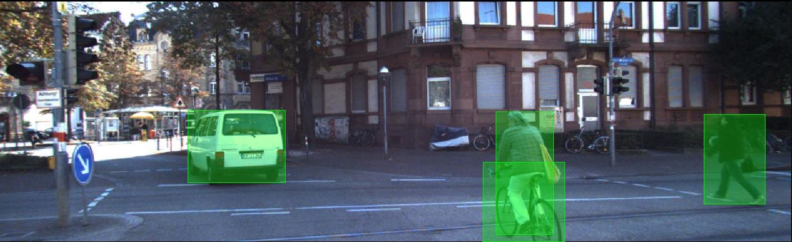
This 2-D image of a street scene has been annotated with bounding boxes. Source: UnderstandAI, a DSpace company.
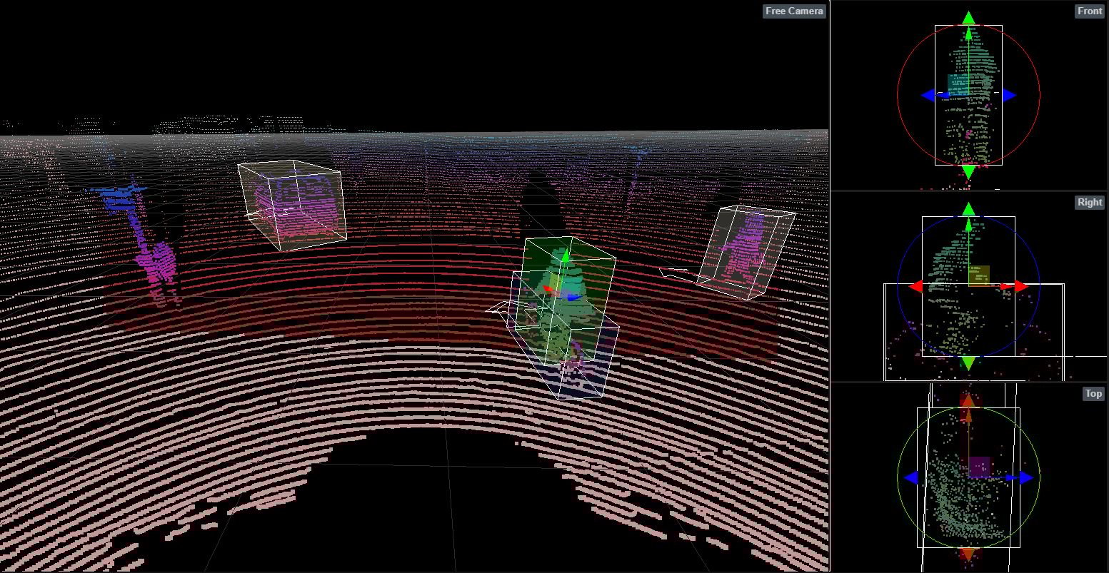
The same street scene is shown here in a 3-D LiDAR sensor image that is annotated using 3-D annotation. Source: UnderstandAI, a DSpace company.
7 Interesting LiDAR Applications
LiDAR is a valuable technology for several industries, from autonomous vehicles to surveying.
Below are seven interesting applications of LiDAR:
-
Aerial Inspection
Drones/UAV LiDAR data provides valuable aerial insight into industrial assets that are difficult to inspect, including power lines, civil infrastructure, and other industrial assets, to reduce operational maintenance costs. -
Precision Agriculture
LiDAR can help agriculture technology companies pinpoint areas to optimize water, fertilizer, and herbicides or manage pest control to improve crop yield. -
Forestry and land management
LiDAR can be used to measure the vertical structures and density of the canopy in forests. This data can then be analyzed for environmental impact, land management, and fire prevention planning. -
Survey and mapping
LiDAR creates accurate maps and digital elevation models for geographic information systems (GIS) to aid civil and commercial surveying and mapping applications. -
Renewable energy
LiDAR can identify requirements for harnessing solar and wind energy, such as optimal solar panel positioning. It can calculate direction and wind speed to allow the operators of wind farms to build and place turbines. -
Robotics
LiDAR is used to equip robots with mapping and navigation capabilities. The technology trains an autonomous system to recognize the distance between the vehicle and other objects in the environment. -
Autonomous Vehicles
For self-driving vehicle applications, LiDAR provides a longer-range alternative to still image and video cameras, which aren’t as effective in poor atmospheric conditions like rain and fog. Vehicles fitted with LiDAR systems collect data such as road markings, traffic signs, pedestrians, road obstructions, and other vehicles.
LiDAR data labeling for computer vision
💡To be useful for computer vision, and more specifically, supervised machine learning, LiDAR data must be accurately labeled, which is a big job that can be difficult to scale.
The challenge for AI developers is transforming massive, raw data into large amounts of structured data that can be used to train machine learning models. That requires hours and hours of data labeling to prepare for training machines to interpret and understand the visual world.
CloudFactory's LiDAR data labeling gets you to market fast
CloudFactory has AI-driven solutions designed for efficient LiDAR data labeling, blending advanced automation with human expertise to streamline the annotation process for industries like autonomous vehicles, urban development, and geographical mapping.
The unique mix of technology and human insight speeds up product development and reduces costs. It also enhances model performance metrics such as mean Average Precision and Intersection over Union, making it critical for businesses focused on optimizing AI and machine learning initiatives.
Data labeling no longer needs to be a major bottleneck, consuming a significant portion of your AI project time and contributing to a high failure rate due to data quality issues.
CloudFactory addresses these challenges by efficiently sourcing and annotating data, applying effective techniques, and reducing time and errors associated with labeling, leading to accurate datasets and faster convergence on ground truth data.

Data Labeling Computer Vision Image Annotation AI & Machine Learning Autonomous Vehicles Geospatial
